Navigating Central Park: A Practical Logistics Guide
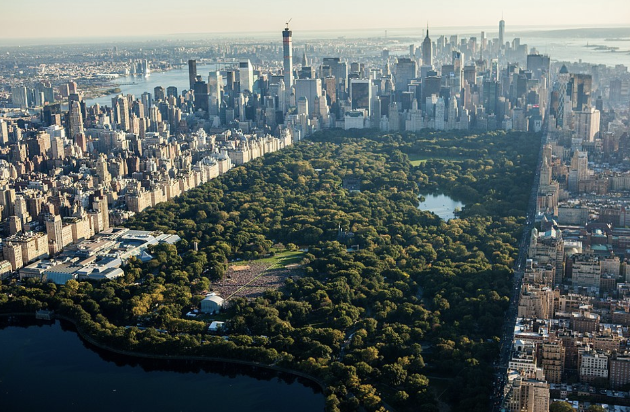
Central Park is not just a park; it is an 843-acre urban ecosystem that serves as the literal lungs of Manhattan. Stretching from 59th Street to 110th Street, its scale often catches travelers off guard. To experience it effectively, you must approach it with a specific plan, as “wandering” without a sense of direction often leads to exhaustion and missed landmarks.
Whether you are looking for the iconic movie-set views of the south end or the quiet, wooded escapes of the north, understanding the transit entry points, bike regulations, and geographic tiers is essential for a productive visit.

| Short answer | Enter below 72nd St for landmarks; go above 96th St for quiet and local vibes. |
|---|---|
| Best for | Walkers, families, and photographers who have at least 2–3 hours to spare. |
| Not ideal for | Travelers in a rush or those expecting a wild, unmanaged natural wilderness. |
| Bottom line | Commit to one section (Lower, Mid, or North) per visit rather than trying to walk the whole 2.5-mile length. |
The park is divided into three informal zones: the Lower Park (59th to 72nd St), which houses the most famous landmarks; the Mid-Park (72nd to 96th St), home to the Reservoir; and the North End (96th to 110th St), which offers rugged terrain and fewer crowds.
✅ When it makes sense
- You have a 3-hour window: This is the minimum time needed to see the “core” landmarks (Bethesda, The Mall, Bow Bridge) without sprinting.
- The weather is temperate: Spring (May) and Fall (October) offer the best visual payoffs with blooms or foliage.
- You are staying in Midtown or the Upper West/East Sides: The park serves as a strategic pedestrian thoroughfare between museum visits (MET to AMNH).
- You need a sensory break: It is the only place in Manhattan where the city’s hum is consistently muffled by greenery.
🚫 When it doesn’t
- During active heavy rain or high winds: The park can become muddy, and the city may close certain areas for safety (falling limbs).
- Late at night: While the park is officially open until 1:00 AM, it is not recommended for tourists after dark due to limited lighting and visibility.
- If you only have 30 minutes: You will barely make it past the perimeter; stick to a quick photo at the 59th St entrance instead.
- When your feet are already sore: Even “short” walks in the park involve significant mileage and uneven pavement.
🧠 Reality check (what most travelers miss)
The most common mistake is underestimating the distance. The park is 2.5 miles long. Walking from the bottom to the top at a casual pace takes over an hour—and that is if you don’t stop. Most visitors find themselves “stranded” in the middle, far from a subway station, because they didn’t realize how deep into the interior they had walked.
Furthermore, cycling is highly restricted. You cannot ride bikes on the pedestrian paths, only on the main “drives” (the paved loop). If you want to see the Bethesda Terrace or the Strawberry Fields mosaic, you must park your bike and walk. Biking is for exercise and broad sightseeing; walking is for the actual landmarks.
The “Iconic Core” Walk
| Who this fits | First-time visitors wanting the “NYC Movie” experience. |
|---|---|
| What to do | Enter at 59th St/5th Ave and walk toward Bethesda Terrace. |
| Watch-outs | Extreme crowds on weekends; aggressive pedicab drivers at the entrances. |
| Local tip | The Gapstow Bridge (at 62nd St) offers the best skyline-meets-nature photo op. |
This route covers the most densely packed area of the park. Start at the Grand Army Plaza entrance and follow the paths toward the Wollman Rink. Continue north to The Mall, the only straight path in the park, lined with American Elms.
This path terminates at Bethesda Terrace. From here, you are steps away from Bow Bridge and Strawberry Fields. This entire loop is roughly 1.5 miles and can be done comfortably in 90 minutes.
The Active Loop (Cycling)
| Who this fits | Fitness enthusiasts and those who want to see the whole park quickly. |
|---|---|
| What to do | Rent a bike near 59th St and ride the 6.1-mile full loop. |
| Watch-outs | The “Harlem Hill” at the north end is a steep, difficult climb. |
| Local tip | Ride counter-clockwise; this is the mandatory flow of traffic for all wheels. |
Renting a bike is the only way to see the transition from the manicured south to the rugged north in a single afternoon. The loop is car-free, but you must share the road with professional cyclists and runners. Do not stop in the middle of the lane for photos.
If you aren’t up for the full 6 miles, use the 72nd St or 102nd St cross-drives to “cut” the park into smaller loops. Note that Citi Bike stations are located around the perimeter of the park, not inside it.
The Quiet North Escape
| Who this fits | Repeat visitors and those seeking silence or birdwatching. |
|---|---|
| What to do | Take the C train to 103rd St and enter at the Conservatory Garden. |
| Watch-outs | Fewer food vendors and public restrooms than the south end. |
| Local tip | Visit The Loch for a hidden waterfall that feels like the Adirondacks. |
The North End is where the park’s original designers allowed the natural topography to take over. It is significantly hillier and more wooded. The Conservatory Garden (at 105th St and 5th Ave) is a designated “Quiet Zone” and features stunning European-style formal gardens.
This area is perfect for a picnic near the Harlem Meer. You will find mostly locals here, and the pace is much slower than the tourist-heavy areas near Midtown.
⚖️ Quick comparison
| Walking | Allows access to every bridge, monument, and hidden path. Best for detail. |
|---|---|
| Biking | Covers the full 843 acres in ~1 hour. Best for overview and exercise. |
| Best pick if… | You want the Bethesda/Bow Bridge photos, choose Walking. |
While pedicabs and horse-drawn carriages are available, they are significantly more expensive and limited in where they can go. Walking remains the superior way to experience the park’s intentional design and intimacy.
🎯 Final recommendation
For the best balance of logistics and sightseeing, enter the park at 72nd Street (either East or West side). This drops you directly into the “Mid-Park” heart, giving you immediate access to The Lake, Strawberry Fields, and Bethesda Terrace without having to trek through the congested 59th St entry points.
Always download an offline map (like the official Central Park Conservancy app) before heading in. Cell signals can be notoriously weak in the wooded “Ramble” area, and the winding paths are designed to be confusing to mimic a natural forest.
Frequently Asked Questions
Is Central Park safe at night?
The park is officially open until 1:00 AM, but for practical safety, it is best to exit by dusk. While major paths near the perimeter are used by runners, the interior becomes very dark and isolated.
Where are the cleanest bathrooms?
The restrooms at the Ancient Playground (near the MET) and the Bethesda Terrace (lower level) are generally the best maintained. Many visitors also use the facilities inside the MET Museum or American Museum of Natural History before entering the park.
Can I bring alcohol for a picnic?
Technically, alcohol is prohibited in NYC parks. While many people discreetly bring wine or beer to the Great Lawn, open containers can result in a summons if a park ranger or NYPD officer chooses to enforce the rule.
Which subway line is best for the park?
The A, B, or C trains run along the West side (8th Ave), stopping at 59th, 72nd, 81st, 86th, 96th, 103rd, and 110th. The N, R, W trains are best for the South end (59th St). The 4, 5, 6 trains run along the East side but are a few blocks’ walk (3 blocks) from the actual park entrances on 5th Ave.
Leave a Reply